Note to readers: This article started out on October 28 as a weather update email to Guy and Morgan (this year's crew) and was revised daily with new information as NOAA updated their forecasts.
As of Friday October 28:
While the Hingham weather has been a bit nasty (gale winds and cold) for the last 6 days (this as of Thurday PM) and is forecasted to remain so through the weekend, the forecasted high pressure mentioned in "Cruising Plans" for Monday and Tuesday has not changed.
Below is the offshore forecast for the mid-Atlantic waters. It's showing diminishing winds starting on Monday and continuing through Tuesday.
This has two implications. The first is near shore wind and seas will be almost flat. The second bodes well for a beeline crossing from Buzzards Bay direct to Ocean City NJ.
ANZ899-290315- 1020 AM EDT FRI OCT 28 2016 .SYNOPSIS FOR MID ATLC WATERS...
A COLD FRONT WILL MOVE SE ACROSS THE NRN AND CENTRAL WATERS TODAY...THEN CONTINUE S OVER THE SRN WATERS TONIGHT WHILE WEAKENING. A HIGH PRES RIDGE WILL BUILD OFFSHORE TONIGHT...MOVE SLOWLY SE INTO THE SRN WATERS SAT AND SAT NIGHT...THEN GRADUALLY WEAKEN SUN INTO MON. ANOTHER COLD FRONT WILL APPROACH FROM THE NW SUN...THEN PUSH SE OVER THE WATERS SUN NIGHT AND MON AS LOW PRES PASSES E ACROSS THE FAR NRN WATERS. ANOTHER RIDGE WILL BUILD SE OVER THE WATERS MON...THEN MOVE SE ACROSS THE AREA MON NIGHT THROUGH TUE NIGHT.
The second offshore forecast below takes us beyond the Delaware River. Look at Weds. We have favorable (2-3 foot) seas into Maryland.ANZ915-290315- BETWEEN 1000 FM AND 38.5N WEST OF 69W- 1020 AM EDT FRI OCT 28 2016 GALE WARNING TODAY W WINDS 25 TO 30 KT. SEAS 8 TO 12 FT. SCATTERED SHOWERS. TONIGHT NW WINDS 25 TO 35 KT...DIMINISHING TO 20 TO 30 KT. SEAS 8 TO 14 FT. SAT NW WINDS 15 TO 25 KT...BECOMING W. SEAS SUBSIDING TO 6 TO 10 FT. SAT NIGHT W WINDS 20 TO 30 KT. SEAS 6 TO 9 FT. SUN W WINDS 15 TO 25 KT. SEAS 4 TO 8 FT. SUN NIGHT W WINDS 10 TO 20 KT...BECOMING N TO NW 15 TO 25 KT. SEAS 4 TO 6 FT. MON N TO NE WINDS 15 TO 25 KT. SEAS 5 TO 7 FT. MON NIGHT E TO NE WINDS DIMINISHING TO 5 TO 15 KT. SEAS 3 TO 6 FT. TUE E TO SE WINDS 5 TO 10 KT. SEAS 3 TO 4 FT. TUE NIGHT S TO SW WINDS LESS THAN 10 KT. SEAS 2 TO 3
ANZ899-290830- 423 PM EDT FRI OCT 28 2016 .SYNOPSIS FOR MID ATLC WATERS...
A COLD FRONT WILL MOVE S ACROSS THE SRN WATERS TONIGHT WHILE WEAKENING. A HIGH PRES RIDGE WILL BUILD OFFSHORE TONIGHT...MOVE SLOWLY SE INTO THE SRN WATERS SAT AND SAT NIGHT...THEN GRADUALLY WEAKEN SUN INTO MON. ANOTHER COLD FRONT WILL APPROACH FROM THE NW SUN...THEN PUSH SE OVER THE WATERS SUN NIGHT AND MON AS LOW PRES PASSES E ACROSS THE FAR NRN WATERS. ANOTHER RIDGE WILL BUILD SE OVER THE WATERS MON...THEN MOVE SE ACROSS THE AREA MON NIGHT THROUGH WED NIGHT. A LOW PRES TROUGH IS EXPECTED TO MOVE OFFSHORE INTO THE NW WATERS WED AND WED NIGHT.
ANZ825-290830- BALTIMORE CANYON TO CAPE CHARLES LIGHT TO 100 NM OFFSHORE- 423 PM EDT FRI OCT 28 2016 TONIGHT N TO NW WINDS 15 TO 25 KT. SEAS 4 TO 7 FT. SAT W TO SW WINDS DIMINISHING TO 5 TO 15 KT...THEN BECOMING SW 10 TO 20 KT. SEAS 3 TO 5 FT. SAT NIGHT SW WINDS 15 TO 25 KT...BECOMING W. SEAS 3 TO 6 FT. SUN W WINDS 15 TO 20 KT...BECOMING SW 10 TO 15 KT. SEAS 3 TO 5 FT. SUN NIGHT SW WINDS 15 TO 20 KT...BECOMING N. SEAS 3 TO 5 FT. MON N WINDS 15 TO 20 KT...DIMINISHING TO 10 TO 15 KT. SEAS 3 TO 6 FT. MON NIGHT NE WINDS 10 TO 15 KT...BECOMING E 5 TO 10 KT. SEAS 3 TO 5 FT. TUE VARIABLE WINDS LESS THAN 10 KT. SEAS 2 TO 3 FT. TUE NIGHT S WINDS LESS THAN 10 KT...BECOMING SW. SEAS 2 TO 3 FT. WED SW WINDS LESS THAN 10 KT. SEAS 2 TO 3 FT. WED NIGHT S TO SW WINDS LESS THAN 10 KT. SEAS 2 TO 3 FT.
As of Saturday October 29:
The forecast below is for the near shore waters at Cape Hatteras, which as you know is the most dangerous stretch of water on our route (and for that matter, the Eastern Seaboard). Because of the impassable Diamond Shoal, which requires us to go 17 miles out to sea to get around it, and the fact that we traverse these waters at night, calm seas are, shall we say, desirable. NOAA is forecasting 2 to 3 footers on Wednesday, which is as far out as they go as of this moment (Saturday AM). We deal with Hatteras on Thursday. The synopsis show high pressure building over the area mid-week. Seas should remain favorable for us.
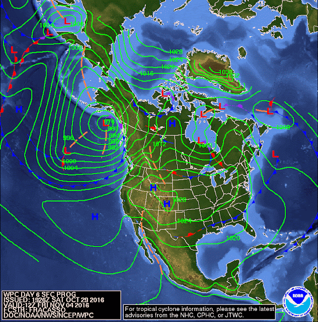
AMZ100-292215- 658 AM EDT SAT OCT 29 2016 .SYNOPSIS FOR EASTERN NORTH CAROLINA COASTAL WATERS... HIGH PRESSURE WILL BUILD OVER THE REGION TODAY WITH ANOTHER COLD FRONT CROSSING SUNDAY NIGHT INTO EARLY MONDAY. HIGH PRESSURE WILL REBUILD OVER THE AREA THROUGH THE MIDDLE OF NEXT WEEK. $$NOAA's forecast map six days out (immediately below), which takes us to Friday (4 days into our journey) shows high pressure approaching the Carolina's with the isobars far apart. This indicates calm seas and, even better, winds out of the northeast giving us a following sea and a slight tail wind.
AMZ154-292215- S OF CAPE HATTERAS TO OCRACOKE INLET NC OUT 20 NM 658 AM EDT SAT OCT 29 2016 TODAY N WINDS 5 TO 10 KT...BECOMING SW LATE. SEAS 2 TO 4 FT. DOMINANT PERIOD 9 SECONDS. TONIGHT SW WINDS 5 TO 10 KT...BECOMING W 10 TO 15 KT AFTER MIDNIGHT. SEAS 2 TO 4 FT. DOMINANT PERIOD 9 SECONDS. SUN W WINDS 10 TO 15 KT. SEAS 2 TO 4 FT. DOMINANT PERIOD 9 SECONDS. SUN NIGHT W WINDS 10 TO 15 KT. SEAS 3 TO 5 FT. DOMINANT PERIOD 8 SECONDS. MON N WINDS 15 TO 20 KT. SEAS 3 TO 5 FT. MON NIGHT NE WINDS 15 TO 20 KT...DIMINISHING TO 10 TO 15 KT AFTER MIDNIGHT. SEAS 3 TO 5 FT. TUE NE WINDS 5 TO 10 KT. SEAS 2 TO 4 FT. WED N WINDS 5 TO 10 KT. SEAS 2 TO 3 FT.
Forecast Friday Morning, November
The high pressure to the west bodes well for the weekend as we cross Georgia and Florida waters. I'm going to go out on a limb and predict that the weather window will be open for 7 days and thus we make Clewiston without a weather incident.Weather is definitely less of a factor on the Okeechobee. Baring high winds and pea soup fog, our Tuesday run from Clewiston to Captiva should be easy. That leaves Wednesday on the Gulf Coast as the only remaining weather question but here too we have the Gulf ICW if needed.
So, bottom line, the sea gods heard my request and we have favorable weather. Sarasota here we come.
As of Sunday morning October 30th:
The following five forecast maps take us out to Friday. What this shows is the weather window (high pressure with a isobars far apart) is "open for business."
 |
| Forecast Monday Morning October 31 Lousy weather but were still at the dock |
 |
| Forecast Tuesday Morning, November 1 |
 |
| Forecast Wednesday Morning, November 2 |
 |
| Forecast Thursday Morning, November 3 |
 |
| Forecast Friday Morning, November 4 (As of October 30) |
 |
| Forecast Saturday Morning, November 5 |
The Saturday forecast above shows high pressure across the entire country. As a weather junky (I study the weather every morning) I can say this is a rare sight. This is far as NOAA goes as of this writing but it is safe to say that we have a weather window all. The way to Sarasota.
I'm not particularly concerned with the cold front just north of the Florida border, which is most likely to be a dry cold front due to the mild pressure gradient (isobars far apart).
As always, thanks to weather gods Zeus and Zephyros.
Explanatory Note: Zephyros is the god of the gentle west wind and the herald of spring. He was the husband of Chloris, the goddess of flowers, and the father of Carpus, fruits. ZEUS, the King of the Gods and the ruler of the heavens, is the god of clouds, rain, thunder and lightning.
Written by Les.


