Friday, May 13, 2016

Hingham Bound: The Crew Visits Boston

One of the challenges for crew members is making reservations for the return flight to their home. Wylie was headed for Chicago while Tom was headed for Michigan. Both made reservations for Wednesday, May 11. Wylie made his well before our voyage started. When I pointed out he was, perhaps, a bit optimistic (i.e., we might have to lay up a day or two for bad weather), he informed me that it was changeable with a $42 fee. Problem solved. Tom made his reservation enroute once we had a reasonable expectation of reaching Hingham as predicted (on May 9).

So, on Tuesday morning we awoke to a spectacular sunny day with a predicted 68 degree high temperature. Diana proposed a trip to Boston. I proposed we wash the boat. Diana's proposal carried the day.

The crew was amazed at the 12 foot tides as shown by the two photos below.

At 8:23 AM we were at dead low tide

Photo of the pilings at low tide
We have an 8 foot margin for a tidal surge
At 10:00 AM we walked to the east side of the marina and caught the ferry to Boston, arriving there just before 11:00 AM after a stop at Logan Airport. Note: Hingham to Boston non-stop is 35 minutes.

Low tide revealing the WWII ways where warships were built 

South Boston viewed from the ferry
Fort Independence at the tip of Castle Island

Boston container port

View of The world trade Center, Fan Pier and Rowes Wharf (Note the arch)

South Boston waterfront looking toward Prudential Center

Logan International Airport

Rowes Wharf complex with its defining arch.
We then took a 6 mile walk through Boston where we visited a number of famous landmarks. Join us on our walk through the city with Tom's photos.

Leaving the ferry dock you walk by a lovely park

Lester, Diana and the Furry Kid (Kodi) in her Southeastern Guide Dog Ambassador Cape at historic Faneuil Hall

Old South Meeting House


Grave of Benjamin Franklin, signer of the Declaration of Independence at Granary Burying Ground


Tour guide in costume telling the story of Mother Goose


Historic Granary Burying Ground

Wylie, Diana and Kodi


Paul revere's grave

John Hancock's grave

Massachusetts State House with gold dome

Entering the Boston Common

Boston Common with the posh Beacon Hill neighborhood to the right

Beacon Hill

Boston Common

Beacon Hill residences

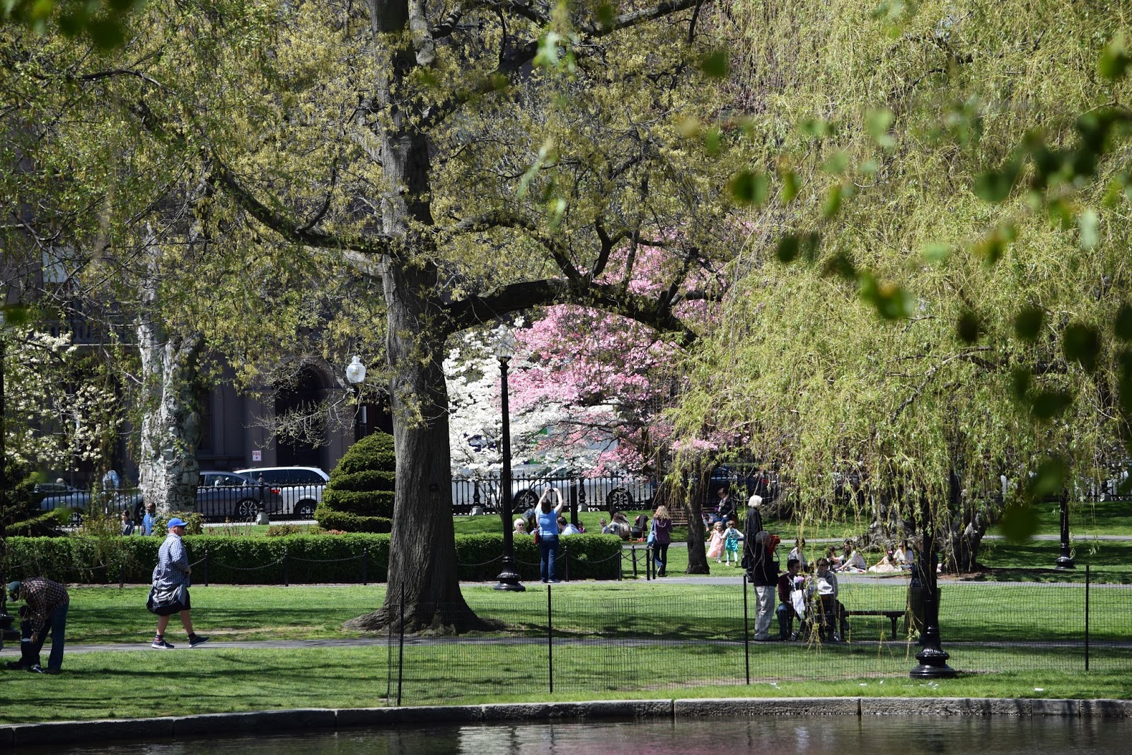
We walk into the Boston Public Garden just across the street from the Boston Common


Kodi, Les, Wylie and Diana strolling through the Boston Common


Monument to Robert McCloskey's famous children's book, Make Way for Ducklings
I read it to Lesley as a child. Now, she and I read it to Amelia (3/1/2)
Shortly Amelia will read it to us.

View of the one of the Garden's famous swan boats


A swan boat loaded with passengers on a beautiful day
The views are spectacular

Spring is busting out all over

Ditto


Old State House

Art in the Union Oyster House depicting historical sites on the Freedom Trail


We stop for lunch at the Union Oyster House, billed as America's oldest restaurant

A street in the North End

Hanover Street in the North End
Lot's of great Italian restaurants

Statute of Paul Revere with the Old North Church in the background

Wylie, Tom, Les, Diana and the Kodi Dog
Arriving back in Hingham at 4:00 PM the crew helped me wash the boat. A six hour job, when I do it alone, took a little over two hours. We did a spectacular job.

Thank you Tom and Wylie for helping me bring Guided Discovery north for the summer. Your efforts, your congeniality and your friendship are greatly appreciated.

That's it folks. The Hingham Bound series is complete. I hope you enjoyed the story as much as I enjoyed telling it.

Written by Les.

Thursday, May 12, 2016

Hingham Bound: Block Island to our Summer Home

The voyage from Block Island to Hingham took 12 hours and was quite pleasant.

At 6:00 AM we officially ended the Atlantic City to Block Island shortcut and switched to the Cape May to Cape Cod Canal route which would take us up Buzzards Bay to the canal. We also estimated our arrival in Hingham to be 3:51 PM.

A tug and a tow following us in Buzzards Bay
The next question was the current speed and direction in the Cape Cod Canal. Would we get a pushed through the canal on a favorable current or would we have to power through against the current.

Buzzards Bay, the Cape Cod Canal, Cape Cod and Cape Cod Bay
Explanatory Note: The 7 mile long Cape Cod Canal connects Buzzards Bay to Cape Cod Bay.  The canal is located in Bourne, Massachusetts. The Massachusetts Maritime Academy defines its southern boundary with the Scusset Beach State Reservation as its northern boundary. A swift running current changes direction every six hours and can reach 5.2 miles per hour during the receding ebb tide. The waterway is maintained by the United States Army Corps of Engineers and has no toll fees. It is spanned by the Cape Cod Canal Railroad Bridge and two highway bridges—the Bourne and the Sagamore. Traffic lights at either end govern the approach of vessels over 65 feet.


We can convert current speed into time for our passage. At slack tide the 7 NM passage would take 50 minutes at our cruising speed of 8.4 knots.  A favorable current, one running northeast at 4.0 knots, would reduce the time to 34 minutes. Likewise, a 4.0 knot current running southwest against us would increase transit time to 95 minutes. To compensate we could increase our speed to 12.4 knots but that would burn about 40 gallons of fuel as compared to about 8 gallons with no adjustment to the throttle setting.

Massachusetts Maritime Academy with the training ship Kennedy in the foreground
The southwest beginning of the Cape Cod Canal
Garmin presents current speed and direction with the chart below. In the upper left hand corner of the upper chart is the current speed, 3.7 knots, in relation to its high and low (+4.0 to - 4.0). The direction of the current is indicated in the lower chart, 83 degrees. 9:58 AM is during the time we were in the canal.


I've always struggled with reading this chart as it relates to direction. Is it coming from 83 degrees or going to 83 degrees? Fortunately, this time I figured it out. The number 83 degrees indicates the direction, northeast, TOWARD which the current is flowing.

Notice the current to the left of the buoy
The magic numbers for us at 9:52 AM as we passed the Massachusetts Maritime Academy were as follows:

  • Current speed: 3.8 knots - a big push
  • Current direction: 83 degrees - favorable direction
Yes!! We have a favorable current. Result. We traversed the 7 NM canal in 34 minutes with GPS speeds of 14.5 knots at the Bourne and 12.2 at Sagamore bridges.

Heading northeast under the railroad bridge with the Borne Bridge ahead 

Sagamore Bridge
Following a tow at the east end of the canal
At 10:28 AM we entered Cape Cod Bay where we turned north. We noted WSW winds at 17 knots, seas of 1 to 2 feet and "a beautiful day on Cape Cod Bay.  


Light at Plymouth  Mass
This changed around 2:00 PM when the wind shifted to the east and increased to 25 knots. Now we were in a 3 to 4 foot head sea, which for the 63 Outer reef is no big deal. We did however add spray and more salt to the already salt encrusted boat.

Boston in view as we pass Cohassett in a 3 to 4 foot head sea
Minots Light off Cohassett Mass
We came within 100 feet in 65 feet of water
As we traveled north we divided responsibilities. Wylie took the con (i.e., the watch), Tom cleaned the ENTIRE interior (and did a FANTASTIC job) and I blogged. The time literally flew by. At 3:25 PM we were abreast of Boston Light. Then 19 minutes later we entered Hull Gut and at 4:00 PM we arrived at Hingham Shipyard Marina.

Boston Light at the entrance to Nantasket Roads
Tom's photo catches the light.
Speaking of light (see photo above). We docked at the Hingham Shipyard Marinas gas dock and took on fuel. What does taking on fuel have to do with light you ask. Readers may recall that I have been struggling with a fuel consumption / remaining question for two years and up to now have been unable to reliably predict the following for both engines:
  • Engine fuel used
  • Generator fuel used
  • Fuel remaining 
Working with Outer Reef and Caterpillar we have reprogrammed the engines Electronic Control Modules (ECM) using Cat's predicted fuel consumption in relation to data I recorded. Ring Power in Sarasota made a final change to the port engine ECM to compensate for data collected last November. They also supplied data for the Northern Lights generator fuel consumption. The number below show we finally, finally got it right.

                                                                       PORT ENGINE       STARBOARD ENGINE
                                                                       & 12KW  Gen          & 16 KW Gen
Engine Fuel Consumed (gallons)                       332                    345
Generator Fuel Consumed (gallons)                    50                      36
Total Predicted Fuel Needed                             382                    381
Total Fuel Added                                               372                    364
Difference (gallons)                                            -10                   -15
Percentage Error                                                 2.6%                4.0%

We were well received. Skip Roper, crew member with Guy Aries on the November 2015 run south to Sarasota, was at the gas dock with Diana and Kodi to welcome us home.

By 6:00 PM we had parked Guided Discovery on her T-Head on I-Dock (her summer home). Diana, Wylie, Tom and I broke out a bottle of champagne to celebrate our successful arrival in Hingham. Then we adjourned to Alma Nove for a celebration dinner.


Guided Discovery on the T-Head for I-Dock
Our summer home
View from the aft deck of our summer home at sunset.
The end of a spectacular voyage
Statistics - Morehead City NC to Hingham, MA:

  • Total Distance: 641 NM
  • Time Enroute: 78.2 hours
  • Average Speed: 8.3 knots
  • Fuel Added: 736.6 gallons
  • Price Per Gallon 2.27 with tax
  • Total Fuel Cost: $1,674.84
Statistics - Sarasota, FL to Hingham, MA
  • Total Distance: 1,421.8 NM (1,635 statute miles)
  • Time Enroute: 8 days and 9 hours (starting from 7:00 AM Sunday May 1).
  • Average Speed: 8.4 knots (Stuart to Hingham)
  • Fuel Added: 1870 gallons (includes non-trip fuel)
  • Avg. Cost Per Gallon: $2.20 per gallon
  • Total Fuel Cost: $4,118
  • Total Cost of Moving Boat: $7,352 (includes Diana's car trip)

Written by Les.

Hingham Bound: Alien Lights in the Night

Montauk Point to Block Island Rhode Island.

Note: You may want to read the previous article "On Golden (Blue) Pond" for context.

We had been on the "Atlantic City to Block Island shortcut" since 5:25 AM on Sunday morning and had covered 168 NM. Except for a dry cold frontal passage at around 2:00 AM Monday, where we saw a sudden wind increase from WNW winds at 15 to NW at 25 to 30 and a slight increase in wave heights (2 to 3 foot rollers of the starboard beam to 3 to 4 footer with whitecaps), we had been experiencing a pretty comfortable ride. That continued all the way to the Cape Cod Canal. So, this is not a weather story.

Explanatory Note: The shortcut is an open water straight line from Atlantic City to Block Island that eliminates the dog leg caused by running the Jersey shore north to Sandy Hook and then turning east to run along the south coast of Long Island. Upside: It cuts off about two hours of travel time. Downside: It put us further out into the North Atlantic thus exposing us to the potential for bigger seas should the weather change and further from shore should an emergency arise. One has to play the Weather Game to handicap the shortcut.

Now it's 1:48 AM and we are abreast of Montauk Point Light on the eastern most point of Long Island. Block Island Rhode Island is the next major landmark about 10 NM further east. I'm on watch. Wylie and Tom sleeping (I hope). I notice ahead some odd yellow lights ahead and assume they are a tow. They appear from my position to be headed further east and I do not have an AIS return or a target on radar. Hence no real concern.

Explanatory Note: Tows typically have AIS (i.e., Automatic Identification System) transponders which enables all other vessels with an AIS receiver to positively identify them. AIS is a satellite based collision avoidance tool. We can both transmit and receive AIS information. With AIS we can see a wealth of information including vessel name, length, type, bearing and distance from Guided Discovery, the vessel's speed and course, etc.

Continuing east the lights continue to be ahead of us. I see a series of five banks of yellow horizontal lights. The first bank, which I assume is the stern of the barge, and the last bank, which I assume is the front, are brighter than banks in the center. I cannot see the classic running lights of the tow but I was not thinking about that at the time (later I realize this was an error on my part).  What concerned me was that the lights were growing bigger and remaining in the same place on the windshield. We are on a collision course with whatever is ahead.

Meanwhile, I'm pondering whether to wake up Tom or Wylie or both but decide not to. I reason if I wake them and ask what do you think those lights are that they will be as puzzled as I. Hence, I let them sleep.

Perhaps the Coast Guard can help and I call them of VHF. I describe what I'm seeing and give my course position in latitude and longitude. They were unable to help. I continue on my course (063 degrees) as the targets continue to get bigger in the windshield.

Explanatory Note: My philosophy is to hold course and speed until I have hard data to dictate a deviation. Over the years I've noted that my crew members have a tendency to want to either slow down, change course or stop when they are unsure of what's ahead. You can waste a lot of time and energy deviating without facts. Hence, unless it's an emergency, the SOP is no deviations without consulting with with me.

Finally, at 3:00 AM off Block Island Light, the objects appear on radar as a line of five targets. Shortly thereafter a tower appears on night vision. That indicates we are within one mile the tower. I call the Coast Guard and report sighting the tower and they confirmed that it was a 5 tower wind farm off the south coast of Block Island. I make a slight deviation to port (see 3rd photo below) As I start passing the towers I wake Tom up - "Tom! Wake up! You have to see this!"

Wind turbine tower on night vision.
Photo by Tom Frakie - Thank you Tom!

The line of wind tower targets falls behind as we proceed east 
Tom goes into action with his camera Nikon camera but has limited success. The two photos above are all he was able to captures as we passed the towers. The photo below shows our deviation and the waypoints I added to mark the location for future trips.

Waypoints marking the Block Island wind farm boundary
Aftermath. I learned a few lessons and pondered a question; Why did the Coast Guard first say the had no idea what I was talking about and then said with absolute clarity, "that is a wind farm off the south coast of Block Island?"

Lessons learned:

  1. Read the Notices to Mariners. Had I read this Coast Guard publication I would have been aware of the new windfarm.
  2. Look for running lights. All vessels have them and their configuration tell what type of vessel you are seeing. 
  3. Keep the Rules of the Road book close at hand. It has illustrations of each running light configuration.

Conversation with the Coast Guard: I called the Coast Guard on VHF and asked that someone in charge call me on my cell phone. Immediately I received a call from Petty Officer Stokes from the Southeast New England Unit. I posed the question to Petty Officer Stokes. He explained that VHF coverage overlaps Coast Guard areas of responsibility and that my first call was received by the New Haven Unit. He further explained that since it was not their area of responsibility they were not aware of the wind farm. I pointed out that since VHF coverage overlaps any unit that can respond to my call ought to be able to provide correct and timely information. Petty Officer Stokes acknowledged that I had a valid point. He promised to take action.

Tom came on watch officially and I stayed on for awhile. Together we watched the sun come up.


"Hours of boredom punctuated by periods of concern (and sometimes stark terror)." Tonight it was just concern.

Written by Les.