Thursday, May 11, 2017

Streaming North: Cruising Off the Continental Shelf

Article started on Sunday, May 7, 2017 at 6:00 AM

Direct Hingham, MA from Georgetown SC

Overview:

The two day weather layover in Georgetown allowed a massive low pressure system to work its way north and east. As it did, widespread high pressure from the Midwest took its place. The forecasts for our proposed route at departure from Georgetown on Sunday at 6:30 AM indicated 15 to 20 knot winds, mostly out of the southwest and west, with following seas 3 to 5 feet from Georgetown all the way to Cape Hatteras, some 213 nautical miles to the east northeast. For the rest of the 600 nautical miles to Massachusetts, the forecast called for diminishing winds and seas around 2 feet.  

The deep low working its way north
We are now predicting arrival in Hingham at 6:00 AM on Thursday morning May 11th using existing programmed routes.  If the forecast holds, we will cover a record 813 nautical miles and, for the second time this voyage, run continuously for four days and three nights. This is truly exciting.

Underway:

We departed Georgetown’s Harborwalk Marina at 6:51 AM and headed 13 NMs south down Winyah Bay to the Atlantic Ocean. Our departure at close to slack tide put us in position for a favorable current.

At 8:44 AM we cleared the Winyah Bay Inlet with an average speed of 8.5 knots and, with full consideration for the forecasted winds and seas, programmed a 220 nautical mile route from that took us direct to Cape Hatteras via Cape Fear (Southport NC) and Cape Lookout (Beaufort NC).

Explanatory Note: This route requires rounding three shoals, Frying Pan at Southport, Cape Lookout at Beaufort and Diamond at Hatteras.  This route can be run close to the coast or offshore. Going close to shore significantly increases the distance traveled as the shoals associated with the capes protrude out many miles (11, 12 and 8 respectively). The near shore route is approximately 268 nautical miles as compared to 220 if run in a straight line.  Those 48 NMs translate into 6 additional hours of travel (and 55 gallons of fuel).

At 5:00 PM on Sunday we crossed the Frying Pan Shoal Slue, a marked shortcut through the shoal with at least 20 feet of water. We noted a following sea, a smooth ride and conditions favorable for continuing to Cape Hatteras offshore in a straight line.

We rounded Cape Lookout Shoals at 3:00 AM on Monday noting a following sea and west northwest winds of 18 to 22 knots and headed direct to Cape Hatteras some 68 nautical miles ahead. We had traveled 167 NMs since leaving Georgetown.

Here’s a question to ponder with regard to the name “Cape Lookout.” Did this cape get its name because it was a good place to “lookout” over the ocean or was the name trying to convey a message – “lookout!!!” The folks who named Cape Fear seemed to be very clear with their message – this is a bad spot. Of course the naming system breaks down at Cape Hatteras, which is without question the most dangerous spot on the Eastern Seaboard. If I were given the naming task I’d call it “Cape Hell,” which it has been on three of our north/south voyages.

Calm waters

Guy at the wheel

Good view of our pilot house instruments
At 11:03 AM on Monday Cape Hatteras was “Cape Easy” with north winds at 10 knots and 2 to 3 foot head seas. Our speed had also picked up slightly owing to the Gulf Stream and our distance off shore. We noted in the log that the head sea we were experience might be standing wave action resulting from the opposing forces of the north wind fighting the Gulf’s northerly flow. Fortunately, the low 10 knot wind velocity only resulted in slight pitching. A stronger wind would have resulted in more violent pitching. We think the lesson is stay out of the Gulf Stream in a northerly wind.

Current sea conditions as we make our decision to go direct Buzzards Bay

Current location of fronts and pressure as we are make our decision to go direct Buzzards Bay

Conditions 24 hours later. We have a weather window
Decision Time: Earlier this morning Bob, Guy and myself performed our morning weather review. The forecast noted in the overview (above) for 3 to 5 foot waves at Cape Hatteras with an improving trend to two footers both near shore and offshore as we progressed north was still valid.  The forecast for calm seas stretched several days.  We had a weather window. This resulted in yet another strategic route decision and another all-time first. We decided to head direct to Buzzards Bay Massachusetts from the tip of Diamond Shoal at Cape Hatteras North Carolina (429 NMs).  This route takes us 85 miles offshore when we are adjacent to New York Harbor. By taking this route we shave off 71 nautical miles and 90 gallons of fuel.


Bob and Guy 
The combined saving in distance, fuel and time from going in a straight line from Georgetown to Cape Hatteras and then to Buzzards Bay is 135 miles, 142 gallons and 16 hours.  The distance from Cape Hatteras to Buzzards Bay is 429 nautical miles.  At 8.4 knots we will cover the distance in approximately 51 hours.

Stow-away. A flying fish landed on the flybridge
At 2:45 PM on Monday we were abreast of Oregon Inlet (just north of Cape Hatteras) running 24 miles from shore. While on this segment the winds became light and variable for almost two hours and the seas calmed to a 2 to 3 foot swell. Time to estimate some arrival times. At that moment, the GPS indicated 396 NMs to the beginning of Buzzards Bay. 

Estimate to:
  • the entrance to Buzzards Bay: 3:00 PM on Wednesday
  • the south end  Cape Cod Canal: 5:00 PM on Wednesday
  • Hingham Shipyard Marina: 1:00 AM on Thursday.
We also noted that the current in the Cape Cod Canal will become favorable at 4:30 PM. It will be fun to see how these estimates play out.

Meanwhile, back to the voyage.

On Monday at 8:35 PM we were 76 NMs east southeast of Cape Henry (Virginia Beach) maintaining an average speed of 8.5 knots thanks to the Gulf Stream. Winds were east northeast at 10 knots. That gave us a 2 to 3 foot quartering head sea and a smooth ride. We were now outside the continental shelf in over 3,000 (three thousand) feet of water.

This photo shows we are outside of the Continental Shelf
As we progressed further north into the evening and early morning on Tuesday the winds and seas decreased to the point where we riding on a beautiful calm sea.  When I took 1 to 4 watch there was very little to do but enjoy the serenity of a moonlit night and listen to James Taylor. Most important, the marine forecasts for our route continued to predict optimum conditions.

Calm waters almost 100 nautical miles offshore
At 4:00 AM, when my watch ended, we were 106 NMs south southeast of Cape May New Jersey (at the north side of the Delaware Bay) and 100 NMs east of Cape Henry (at the south side of the entrance to the Chesapeake Bay) in placid waters with no traffic within 24 NMs (according to the radar).

Explanatory Note: Running almost 100 miles from shore and more than 100 miles from a navigable inlet and shelter of a marina or anchorage is serious business. One should not undertake such a voyage without a weather window that covers the enroute period and even beyond. A “surprise” change in the weather does not leave many options when your boat’s cruising speed is 8.4 knots and its top speed is 13 knots with a 50 GPH fuel burn. Heading for shore/shelter is an 8 hour 400 gallon proposition at top speed (assuming you have enough fuel). Bottom line. A trawler like the 63 cannot out-run the weather. The “good news” (sort of) is that the 63 is rated “Ocean A - Unlimited.” She can handle anything - but why.  The other consideration is mechanical reliability. Alongside of aggressive maintenance, we visit the engine room every 4 to 6 hours to verify the working of our machinery.

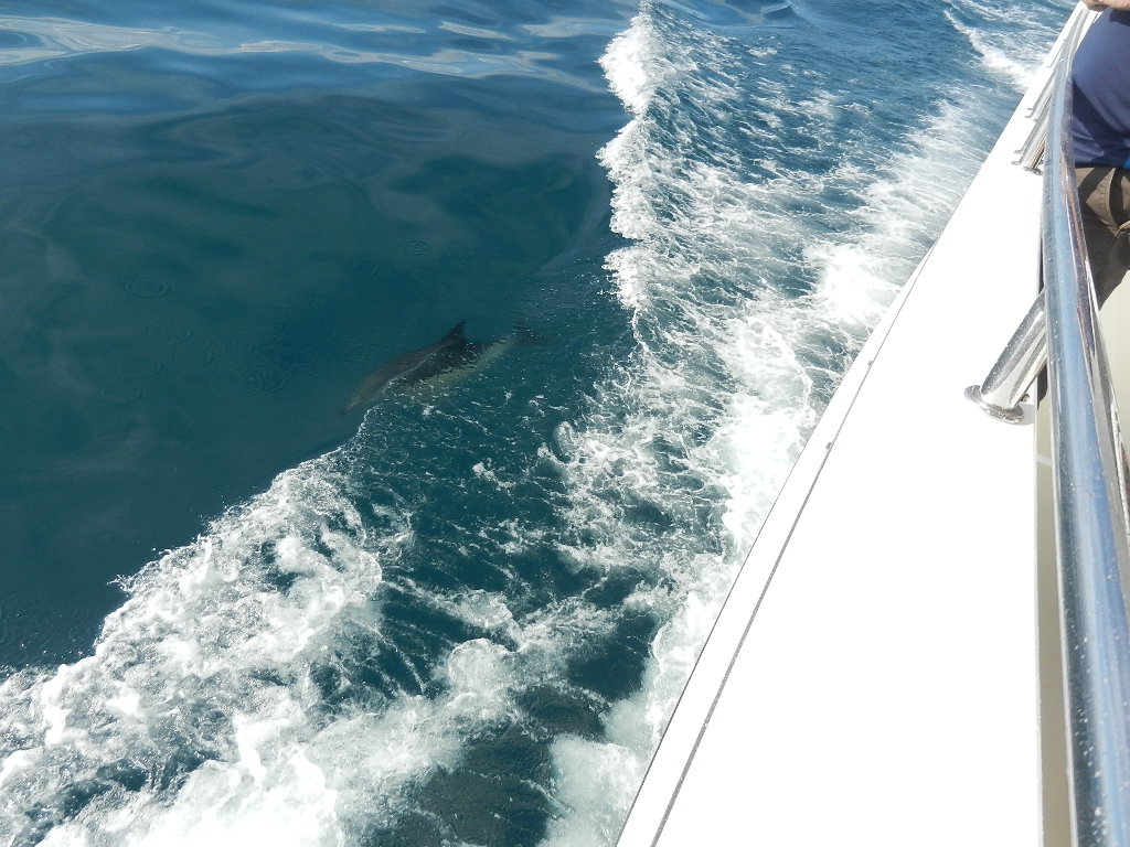
We had several visits from dolphins

Dolphin off the starboard side


Dolphins riding the bow wave
On Wednesday, May 10, 2017, when my 1 to 4 watch began, we were 90 NMs southeast of New York City and 119 NMs from the entrance to Buzzards Bay. Still way offshore in perfect conditions. Our ETA to Buzzards Bay was now 4:25 PM (Wednesday). When my watch ended at 4 AM it had improved further to 3:41 AM.

Earlier on Tuesday afternoon (15:10 log entry) our speed continued to decrease. We noted a current speed of 7.0 knots, a drop of 1.4 knots from our 8.4 average (which is also the 63s optimum cruise speed). Sirius’ water temperature chart (called “Fishing”) showed us in cold water off the continental shelf. We hypothesized that we were running against the Labrador Current that comes down from the North Atlantic and which causes the Gulf Stream to veer east northeast past Cape Hatteras. Whether that is true or not, it did not alter the fact that we would not achieve our 3:00 PM ETA to the beginning of Buzzards Bay or the favorable push through the Cape Cod Canal that begins at 4:30 PM.

This caused us to consider the impact of the speed decrease in relation to the current at Buzzards Bay and the Cape Cod Canal. Basically, we would reach Buzzards after the current began to flow south, which would result in an average 3.0 knot speed reduction over the 25 NMs to the east end of the Cape Cod Canal. We pondered an immediate increase to our speed. To counter the lost 1.4 knots we would have to increase RPMs to 1700 (9.9 knots). However, the fuel burn at 16 gallons an hour shot that idea down as it almost doubled fuel consumption. 24 hours are needed to cover the 194 NMs to reach Buzzards at 3:00 PM. This would result in an additional fuel burn of 216 gallons (over $500). We concluded that it did not make sense given our projected arrival in Hingham in the early morning hours and the fact that we were not up against a deadline. Further, we again hypothesized that our speed might just increase as we crossed over the Continental Shelf and returned to shallower water.

So back to 4:00 AM and the end of my watch. Our ETA was now 3:41 AM. Was our hypothesis correct? Who knows. But the result is the same. As of this moment, we traverse Buzzards Bay and the Cape Cod Canal on a favorable tide.

We made our first landfall in days when we visually spotted the wind farm off Block Island at 10:35 AM. It was 19 NMs west of our position.  At 12:30 PM we were adjacent to Block Island, 11 NMs to the northwest. Winds were west at 10 knots and seas were less than 2 feet.

Bob watching a pusher tow overtake Guided Discovery


As we approached Buzzards Bay we began seeing fishing buoys and lobster pots. We used these "obstacles" as an opportunity to practice spotting and dodging small objects with our FLIR night vision. Great fun - kind of like a video game.

At 3:51 PM on Wednesday we reached the the entrance to Buzzards Bay and the beginning of the home stretch.  Best of all we arrived just as the tide turned to a northerly flow giving us an increase in speed.

Tide Turning Positive just as we enter Buzzards Bay 

By 6:40 we had reached the Hogs Island Channel, which marks the beginning of the Cape Cod Canal. We saw a 4 knot increase in speed to 12.5 knots and a top speed of 13.5. Note: The 63 can barely reach 13 knots and when it does it is burning 50 gallons an hour. The current was pushing us at our top speed while are fuel burn remained 9.1 GPH. Life is good.

Railroad lift bridge at south end of the Cape Cod Canal

12.8 knots current speed and 13.4 top speed in the Cape Cod Canal

3.2 knot current at the Sagamore Bridge
Current moving toward 92 degrees (a northerly flow)
The Sagamore Bridge as viewed on FLIR night vision
At the east end of the Cape Cod Canal we turned north and headed for Hingham. Five and a half hours later at 1:00 AM on Thursday, Guided Discovery was sitting at the dock. We had hit the arrival time that we predicted three days earlier to the minute.

Heading north from the east end of the Cape Cod Canal to Hingham
Moon rising over Cape Cod Bay 
This amazing voyage was over but, clearly, it was one for the record books. 

Segment Statistics:
  • Total Segment Distance: 745 NMs
  • Average Speed: 8.4 Knots
  • Top Speed: 13.5 Knots        
  • Engine Hours: 91
  • Engine Fuel Consumed: 872 gallons
  • Fuel Efficiency: .85 GPNM
  • Generator Fuel Consumed: 93 Gallons
  • Total Fuel Consumed: 964 Gallons
  • Fuel Remaining: 336 Gallons (186 usable based on a 10% reserve)
Trip Totals
  • Total Distance: 1,513 NMs     
  • Engine Hours: 174
  • Engine Fuel Consumed: 1,667 Gallons
  • Overall Engine Fuel Efficiency: .91 GPNM
  • Generator Fuel Consumed: 211 Gallons
  • Total Fuel Consumed: 1,878 Gallons
Written by Les.

Streaming North: Downtime in Downtown Georgetown

Reader's Note: This article was finally completed on May 31.

Well it's the Great Loop all over again. Well, at least in terms of the activity on this stop. During our Great Loop adventure Diana and I (and, of course, Kodi) visited 135 cities as part of the experience. Our visit to Georgetown on this trip was necessitated by the need to stop to wait out a massive low pressure system that brought high winds and big seas to the coast between Charleston and Norfolk.

Back in the Great Loop days our first action when visiting a new city was a get a feel for the area. We did this by visiting www.city-data.com and www.wikipedia.com.

Georgetown has a population of 9,054.  Median income is $25,481 as compared to South Carolina's $47,238. Estimated median condo and home value is $121,514 versus SC's $148,600. The data suggests a small town with a low cost of living.

Drawings showing Georgetown and its location on Winyah Bay and location in South Carolina
Georgetown, founded in 1527, is the third oldest city in South Carolina and the county seat of Georgetown County. Located on Winyah Bay at the confluence of the Black, Great Pee Dee, Waccamaw and Sampit Rivers, Georgetown is the second largest seaport in South Carolina, handling over 960,000 tons of materials a year.

Closed steel mill
The principle employer is a paper mill. A steel mill originally owned by the Kork company of Germany opened in 1973. The steel mill was subsequently financed in 1993 by Bain Capital (Mitt Romney) and was called Georgetown Steel. It declared bankruptcy in 2001 and closed the plant in 2003. The plant subsequently reopened under new ownership but closed in 2015 due to the influx of cheap foreign steel.

Cruise ship Grande Mariner arriving in Georgetown
Tourism has become a booming business. In addition, many retirees have chosen to settle in this area of beaches, plantations redeveloped as residential communities, and pleasant climate. This was evident by a downtown that had restaurants, tourist oriented stores, a harbor walk, tour boats and a visiting cruise ship.


The Grande Mariner, a 184 ft cruise ship of the Blount Small Ship Adventures line, visits Georgetown on Day 4 of their 12 day 11 night Savannah to Baltimore cruise (starting at $3,699). The ship docks at Harbowalk Marina and takes up the entire gas dock and blocks the slip that Larry had put us in.

Here's what Blount says about Georgetown.

Day 4
Georgetown, SC
Georgetown, widely accepted as the probable site of the first European settlements was at the center early American history. Today, the Georgetown Historic District is a picturesque, coastal town filled with buildings and sites listed on the National Register of Historic Places. You can take in its southern charms on walking or tram tours, visit one of its four museums, or test your nerves on its famous ghost tours.

184 ft Grande Mariner blocking the 50 ft Hatteras 
Grande Mariner arriving at the dock
The folks on the Grande Mariner had about 6 hours of "shore leave," which is not a lot of time to get to know a city. We had two full days and even engaged in "commerce" as we did some light provisioning at the Piggly Wiggly and purchased a hose at a plumbing supply store in a fruitless attempted to fix a broken waterline to the master head toilet.

Guy and Bob posing at the William Doyle Morgan House with supplies picked up in town


William Doyle Morgan House

Another home in the historical district
Larry and Bob

Friday and Saturday there was free entertainment on Main street


The Harbor Walk

Guided Discovery and the Grande Mariner cruise boat as we walked along the harbor walk

How about a little history?

Kaminski Building and the Town Clock

Stores on Main Street


Written by Les.


Saturday, May 6, 2017

Streaming North: Confidently Cutting Close on Fuel

So it’s 1:00 AM on Thursday morning and were headed for Charleston as I take over the 1 to 4 watch from Bob. We had been watching the weather closely throughout the trip and suspected that we may run into stormy weather as we headed north. After making the 1:00 AM log entry and performing an engine room check, I focused on the weather for Cape Hatteras, the most challenging stretch of water on the entire 1600 NM voyage. Below is what a saw:


The forecast for Cape Hatteras to Ocracoke Inlet showed that starting on Thursday night wind and seas would continue to increase pretty dramatically. This was due to the formation of a deep low pressure system over Alabama and high pressure over New York that was drifting slowly east into the Atlantic.  This combination coupled with a frontal passage at Cape Hatteras foretold extremely rough seas over a wide area.

Deep low pressure over Alabama drifting east with high pressure over New York slowly lifting into the Atlantic
Cold front approaching the coast in 48 hour
As noted in the forecast photos above, the conditions at Cape Hatteras would not improve until late Sunday. Monday's forecast called 2 to 4 foot seas, which is great for traversing Cape Hatteras. Stopping and waiting for the weather to clear was clearly in the cards,

Explanatory Note: My decision to head further north on minimal fuel reserves is based on three years of experience with the 63. That experience includes two ECU adjustments by Caterpillar to correct a discrepancy that showed fuel consumption readings below the actual amount of fuel consumed. It also includes fill-ups after runs in excess of 600 miles where I was able to predict the amount of fuel added with 20 gallons in each 500 gallon tank (A .04% error rate).

Decision Time: At 9:25 AM on Thursday, Bob and I (yes, again, Guy was sleeping) made a decision to head for Georgetown South Carolina where we planned to stay for at least two days waiting for the weather to improve. This decision, which put us at or below the 10% fuel reserve, had several major components:
  1. At 9:22 AM we were sitting on 220 gallons of fuel as measured by the site glasses on the fuel tanks. The tank tender's "worst case" measurement was 126 gallons (see Explanatory Note below).
  2. The additional distance to Georgetown was 65 nautical miles. That translates into approximately 75 more gallons of fuel consumption.
  3. A forecast for 4 to 6 foot seas in the late afternoon between Charleston and Georgetown.
  4. Current wind conditions were southeast at 22 knots. This would produce a sea on the starboard forward quarter and a relatively stable ride owing to the stabilizers.
  5. The 13 NM run up Winyah Bay would be on calm water reducing the risk of an engine stoppage from unporting a fuel line
  6. The marinas in Georgetown are in protected waters - critical as storms were approaching from the west.
  7. Heading to Charleston City Marina (aka the Mega Dock) would add 13 nautical miles from our arrival point at the inlet (and another 13 nautical miles to return to sea)
  8. Diesel fuel price at Georgetown was $2.27 versus Charleston at $2.74. 
At 9:50 AM we changed course for Georgetown just south of Charleston channel. We had covered 705 nautical miles since leaving Sarasota four days earlier. Our current speed was 8.0 knots (as we were out of the Gulf Stream). The engine monitors showed 720 gallons of fuel consumed. Add to that approximately 72 gallons of generator use and we have a total fuel burn of 794 gallons.

Five hours later, we arrived at the Winyah Bay inlet and headed north up the bay to Georgetown. 


Approaching Harborwalk Marine in Georgetown
You can barely see their Phillips 66 sign
Finally, at 5:23 PM we arrived at the Harborwalk Marina fuel dock. We were greeted by Larry and promptly started the process of refueling. Note: Larry gave me a $2.17 fuel price based on an expectation of over 1,000 gallons.

When fueling was completed we had taken on 1,205 gallons, which includes refilling the auxiliary tanks. So to fully understand our fuel situation we need to focus on the 960 gallons of fuel in the main tanks at the start of the trip.

Recall that we left Sarasota with 960 gallons in the main tanks (500 gallons each) and 31 gallons in the auxiliary tanks (which were essentially unusable). That translates into 480 gallons in each main tank. At Harborwalk I added 468 gallons to port ad 466 gallons to starboard.  The site glasses overstated fuel remaining showing port with 50 gallons remaining and starboard with 60 gallons. The Tank Tender showed port with 21 and starboard with 29 gallons remaining. No question that we cut it close (with at least two hours of running time left if you go with the Tank Tender readings). Again a calculated risk, which in this case included total confidence in the fuel consumption data put out by the engine monitors and the fact that the last hour of the trip was on the calm waters of Winyah Bay.


Guided Discovery at Harborwalk Marina with approaching storm clouds

Summary: This trip established many new records: 
  • The longest distance traveled (766 nautical miles)
  • The first trip around the Florida keys (with the 63)
  • The most fuel purchased at any one time (1,205 gallons) 
  • A fuel price within 4 cents of the lowest price we've paid since acquiring the 63.
  • The first "ride" in the Gulf Stream
  • The fastest enroute speeds
  • The shortest time enroute. We were 19 hours ahead of schedule when we arrived at Georgetown inlet.
  • The first trip in three years with with down time due to weather (2 days)
  • The lowest amount of fuel  remaining at trip end.
Statistics:
  • Total Distance: 766 nautical miles (740 since the Venice Inlet)
  • Average Speed: 9.4 knots
  • Maximum Speed: 14.9 knots
  • Engine Hours: 83
  • Engine Fuel Burned: 795 gallons
  • Generator Fuel Burned: 100 gallons
  • Total Fuel Burned:  895 gallons
  • Fuel Needed: 1,164 gallons (895 + 269 gallons to fill the auxilliary tanks)
  • Fuel Purchased: 1,205 gallons
  • Fuel Cost (at $2.17 per gallon): $2,614.8
Written by Les.