Thursday, March 28, 2019

Crewing to Annapolis: The Journey Begins

How about another voyage north?

Wayne, the new owner of the 63, which, by the way, still bears the name Guided Discovery, invited me to join him and his crew on a voyage to Annapolis Maryland. What a deal. I get to do the my favorite activity, long distance cruising without the expense (which over the years averaged about $8,000 per trip from back and forth to Hingham). Talk about having your cake and eating it too.

Note: The 63's new name is Calypso.

Wayne is an very experienced sailor with a number of long distance cruises under his belt. Additionally, following the boat's sale I spent the better part of a week helping him master the 63's systems and operation. Given that we had worked well together, I jumped at the chance of joining him and his crew on this adventure. I also saw it as an opportunity to help him with any issue where he might still have questions.

Other crew members include Wayne's brother David, who I met during the ownership transition, along with Brad Mahood and his wife Sarah. David has extensive sailing experience as do Brad and Sarah. Incidentally, Brad and Sarah are very adventurous. They had just returned from a cruise to Tonga (in the South Pacific for those of you, who like me, didn't have a clue as to where Tonga is). They also snow ski, cross country ski and kayak. To give you a sense of their adventurous nature, they have multiple pairs of skis and at least 15 kayaks.

Departure was scheduled for Monday March 25 and I joined the crew promptly at 9:00 AM. Upon arrival, I determined that Wayne had things well in hand. The boat was provisioned and ready to go - well not quite. Wayne had the presence of mind to check with Marina Jack Services to verify that they had cleaned the bottom. They hadn't. No problem, Joe Campbell, Marina Jack's Service Manager expedited a bottom cleaning and in 60 minutes we were ready to go.

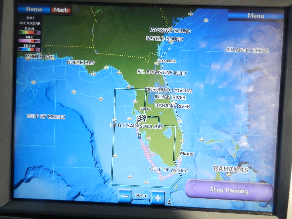
Turns out we were not in a hurry. We had previously decided to depart around 11:00 AM to reach the Seven Mile Bridge at Marathon in the early morning on Tuesday. The last 10 miles before you reach the bridge is riddled with low water and shoals. Arriving in the early morning allowed us to traverse the area close to high tide.

So, at 10:32 AM we departed Marina Jack with a "sparkling" clean bottom. Wayne had wisely chosen to depart Sarasota via the Gulf Intracoastal Waterway (GICW) to Venice rather than "braving" the shallow water at Big Pass.

Approaching the Blackburn Point Swing Bridge
The weather was absolutely beautiful and the run down the GICW was scenic and uneventful. We arrived at the Venice inlet at 12:54 PM and made our way into the Gulf of Mexico.

The sea conditions in the Gulf were perfect with a light northerly wind and seas of less than one foot.

At mid afternoon we performed our first engine room check and discovered two issues, uneven readings on the fuel tank site gauges and water in the forward engine room bilge. With regard to the latter, we surmised that Ring Power had used the fresh water wash-down hose to clean up after replacing the oil pan seal on the port engine. Historically (i.e., for the last 5 years) I have never had any water in the engine room bilge unless there was a problem. So we vacuumed up the water and several hours we rechecked the bilge. It was dry.

The uneven fuel level on the main tanks was more of a puzzle. We found the port tank site gauge indicating full after 7 hours of running. It should have indicated a reduction of 30 gallons (as each engine burns 3.5 gallon per hour at our normal cruise of 8.4 knots).  The starboard gauge showed 60 gallons used. We checked the fuel manifold levers and determined the both engines were pulling fuel from their respective tanks, which therefore ruled out the possibility that Ring Power had changed the fuel source. That at best was a remote possibility.

We problem solved this one by reviewing what had occurred during the previous day's refueling project. Turns out the port tank had overflowed (yes it spilled some fuel BUT NOT IN THE WATER. Fuel overflow goes onto the deck). The starboard tank had not overflowed and we suspected that the person doing the fueling on the port side (full disclosure here - it was Wayne) had not heard the gurgling that occurs seconds before the fuel overflows. To Wayne's defense, fueling the 63 can be tricky.

Explanatory Note: As readers know, I am a bit OCD when it comes to fueling. I always wanted to head north or south with absolutely full tanks. Over the years, and due to my long distance runs, We have run the tanks close to empty on several occasions.

Later in the day, we were able to confidently conclude that the port tank had been "filled to the brim" and that the starboard tank was short approximately 30 gallons.

The lovely cruising weather continued through the night and we arrived at the Seven Mile Bridge at 8:49 AM on Tuesday morning. Next decision. Run the Hawk Channel or venture out into the Gulf and pick up the Gulf Stream. We chose the later and ventured out beyond the reef (which is appropriate given the fact that we were on a "Outer Reef.")

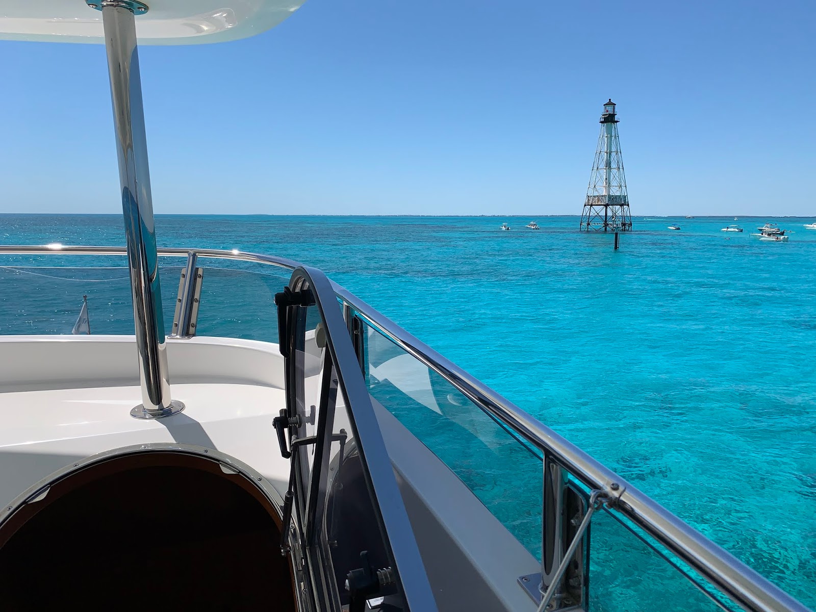
Approaching the Seven Mile Bridge
Here's a first. We stopped at Alligator Reef and all of the crew, including yours truly, went snorkeling. It was great fun. The stop lasted about three hours and after a casual lunch we got on our way.


Another beautiful evening, which included being on flat calm water at for several hours with zero wind. At a point we picked up the Gulf Stream and watched our speed increase dramatically.

Departing Alligator Reef and headed for deep water to pick up the Gulf Stream

We passed Miami at 10:31 PM on Tuesday and continued north eventually stopping in Fort Pierce. We had covered 402 nautical miles when we arrived at the Fort Pierce City Marina at 10:25 AM on Wednesday.

Those of you who have followed my blog may have noticed that I have not spoken much about the weather except to say that it was beautiful. Well, there is clearly a story here. Stay tuned.

We are in calm seas as head for Miami - but there's big weather ahead
Written by Les.


2018 Voyage from Hingham to Sarasota

This article is a bit delayed. Read on and you will see why.

The crew for this voyage was Guy Aries, making his fifth trip and a newcomer, Gary Gruska, who I met in Sarasota at Whole Foods while months earlier.

Here too there is a bit of a story. I had walked up to Whole Foods from Marina Jack with Kodi to pick up a few items. As is my custom, I find someone to watch Kodi while I go into the market. Gary and his wife, Sally, looked like upstanding citizens so I chose them.  Finished with shopping, I returned to retrieve the "retriever" also know as the "Furry Kid."

I thanked them for dog-sitting and, again, as is my custom, I had Kodi perform a few behaviors including her counting skills. They were fascinated and we spent a few minutes conversing. In the process I told them that I live on a boat and regularly "commuted" between Sarasota and Hingham. Bottom line, I extended an invitation to Gary to join me for the return voyage in the fall.

The crew assembled in the late afternoon on Wednesday, October 31, 2018 and, instead of waiting until Thursday morning for our traditional 7:00 AM departure we made preparations and got underway. This ultimately proved to be a bad move as it threw us off the schedule. Most significantly it eliminated the traditional stop at Morehead City, as they would be closed when we arrived. It also put in the Cape Cod Canal just after midnight fighting a 4 knot current.

The crew: Guy Aries and Gary Gruska
Once out of the canal and Buzzards Bay we proceeded south southwest toward Sandy Hook New Jersey along the south coast of Long Island. Seas were 4 to 5 feet of the port forward quarter with a period of 8 to 10 seconds. The longer wave period actually contributing to a fairly smooth ride.  This continued all the way to Sandy Hook, which we reached at midnight on Thursday.

From there we set a direct route to the Cape May (NJ) inlet. Winds at the time were south southwest at 24 knots. The run south from Sandy Hook was less friendly with occasional seas running 8 to 10 feet. This resulted in taking seas over the bow.

We arrived at the Cape May Harbor entrance at 3:00 PM and proceeded to Utches Marina, arriving at the dock at 3:30 PM. Given the rough seas we decided to spend the night at Utches rather than continue to get beat up. Since leaving Hingham we had traveled 336 nautical miles. We took on 477 gallons of fuel. Utches' price was a reasonable $3.15 per gallon (We spent $1,503 to top off the tanks.)

Owing to the rough seas in the Delaware Bay we delayed our departure until 11:33 PM on Saturday. As we departed Utches I screwed up and ran aground at idle speed. I then used the engines to refloat the boat and, in the process, bent a blade on the port propeller. This was clearly a screw-up on my part and I cannot fathom how I made this error. That said, the folks at Utches, knowing we were transients could have reminded me of the "local knowledge" to exit the marina and turn left to run along their breakwater. Still the error is clearly mine. I should have asked.

Once underway, we headed for Maryland Beach as we crossed the Delaware Bay. At the start of this leg the seas were 6 to 8 feet. They subsided to 2 to 3 feet as we headed south across the bay. What we now noticed was that fuel consumption had increased by 60% on the port engine, which was now consuming 8 gallons per hour as compared to the starboard engine that was consuming it normal 5 gallons per hour. The handwriting was on the wall that we would need a second fuel before reaching Sarasota.

At 3:20 AM on Sunday morning we were crossing the Chesapeake Bay in 3 foot seas. My notes show that the forecast to Diamond Shoal off Cape Hatteras was holding up well with continued 3 foot seas. Essentially, our layover at Cape May allowed the rough weather to pass.

At 10:53 AM on Sunday we were just off the Oregon Inlet, which is north of Cape Hatteras. Winds were east northeast at 26 knots resulting in 4 to 6 feet seas with an occasional 8 footer. However, the 7 second wave period resulted in a rolling sea.

The forecast for south of Cape Hatteras to Oregon Inlet called for 15 to 20 knot winds and 4 to 6 foot seas with a period of 6 seconds for the rest of the day. Then east winds 15 to 20 with seas building to 5 to 7 feet with a 6 second period after midnight. By Monday morning winds were forecasted to diminish to 10 to 15 knots out of the south with a chance of thundershowers. This would produce a head sea but fortunately with low winds.

At 3:27 PM in the afternoon we reached R2 at the southeast end of Diamond Shoal (Cape Hatteras) and turned southwest. Winds were east southeast at 15 knots with 3 to 5 foot waves in a following sea. The forecast called for diminishing winds and seas as we headed direct to Cape Lookout, which we reached just before midnight. We then headed direct to Cape Fear (south Carolina), which we reached at 9:42 AM on Monday morning. Winds and seas continued to diminish making for a very pleasant ride.

We continued south in relatively calm seas reaching the St Mary's River (Fernandina Beach) at 3:22 PM. We then headed into Fernandina Beach inlet for the fuel dock at Port Consolidated where we took on 963 gallons at a spectacular price of $2.886 per gallon. The bill came to $2,793.20.

Explanatory Note: I've been keeping a record of fuel purchases since taking delivery of the 63 in February on 2014. At that time, diesel fuel prices were in excess of $4.00 per gallon (we paid a high of $4.24 per gallon). Fortunately, marine diesel fuel prices over the last 5 years have continued to fall. This resulted in my average fuel price price reducing to $2.87 per gallon. My records show that over these 5 years we used just short of 19,000 gallons. That translates into a total fuel expense of $57,093.

We departed Port Consolidated at 6:00 PM and headed for the open seas along the Florida coast. Wave heights were under 3 feet making for a comfortable ride.

Early Wednesday morning (November 7) we were 22 nautical miles north of the Ponce de Leon inlet (i.e., in the vicinity of St Augustine) in 2 to 3 foot seas owing to light southwesterly winds. This continued as we made our way south along the east coast of Florida.

We passed the Stuart inlet late on Wednesday evening (9:25 PM). Just after midnight we encountered an isolated heavy thunderstorm with heavy rain and lightening in the vicinity of the Lake Worth Inlet (Boca Raton). I noted in the log that it was like going through a car wash.

As dawn broke on Thursday morning we were advised by the United States Navy of maneuvers just south of Port Everglades (Fort Lauderdale). We contacted the Navy ship. They gave us permission to traverse the area if we stayed within 1/2 mile of shore.

At 8:54 AM we were 2 nautical miles east of Soldier Key which is just south of Miami in 2 foot seas with an east wind at 15 knots.


We then proceeded south and west along the Hawk Channel on our way to Marathon and the Seven Mile Bridge


At 10:27 AM on Friday we were off Boca Grande Light heading north toward Venice in calm seas.

We reached Venice at 1:38 PM in the afternoon on Friday and proceeded into the Venice Inlet for the final leg of the journey, which would be on the Gulf ICW between Venice and Sarasota. We elected to run north on the ICW rather than chance a grounding in the shallow water at Sarasota Big Pass.

The following are photos of our journey from Venice to Sarasota on the ICW. This segment toook under two hours.

Heading west down the Venice Inlet

Passing the Crows Nest Restaurant in Venice
 
Heading north of the toward the bridge
 
The railroad bridge opens for us

Sight seeing - a lovely home on the ICW
 
Stickney Point Bridge opening for us

Siesta Key bridge - the journey is almost at end
 
We approach Sarasota and Marina Jack

Gary, Les and Guy pose for an end or journey photo
We arrived in Sarasota at 3:25 PM on Friday afternoon. We had covered a total distance of 1,586.4 nautical miles.

Written by Les.