In my last article I predicted that we would complete the 1438 nautical mile (1651 statute) trip to Hingham in 9 days if the weather cooperates. Well, it's time to see if that will be the case.
Explanatory Note 1: NOAA's forecasts only go out for 6 days. Hence, at this moment we can only make estimates through Friday. Each day, NOAA adds another day to the forecast. So by Tuesday we will have the predictions for the entire route.
Explanatory Note 2: My strategy for evaluating weather starts with getting the big picture. This is accomplished by checking the radar and satellite maps. This gives me a view of precipitation and cloud cover occurring nationwide. Then I go to forecast map for the current conditions (fronts, high and low pressure and pressure gradient). Then I look sequentially at the forecast for the next six days. With that information I begin to formulate my own estimate of the marine conditions and the potential for a weather window. Then I consult the marine coastal forecasts to confirm if I'm on the right track. When not cruising I look at two critical locations, Cape Hatteras and Cape Cod, as they often have the most severe conditions. I find that the conditions in the near shore forecasts are often better (i.e., lower winds and seas). Once hurricane season starts I often begin the process by looking at the active storm window to check the two and five day outlook.
A check of the active storms window today no storms and forecasts no activity for the next five days. This is good. Last year when we made this journey, Tropical Storm Anna was situated south east of the Bahamas and moving slowly. Anna influenced the sea conditions from Fort Pierce to Cape Hatteras and produced for us a very challenging 500 mile journey, with waves at one point reaching 10 to 12 feet. For more information read my articles from last May.
Here's the situation as I currently sea it.
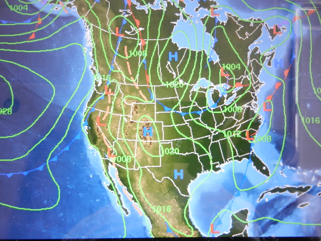
The NOAA weather chart below is for mid-day Sunday. An area of low pressure stretching from Missouri to eastern Ohio with a trailing cold front in southern Illinois stretching to southern Texas is making its way east with associated thunderstorms and heavy rain.

This appears to be good news. The area of predicted rain and thunderstorms stops at the Florida Panhandle suggesting good weather for our 7:00 AM Sunday departure. Further, the storms moving eastward will have plenty of time to clear the eastern seaboard by the time we get to Fort Pierce, which we estimate to occur around 7:00 PM on Tuesday evening.
The forecast below is for Wednesday. By Wednesday we will be making our way north along the Florida coast. The areas of low pressure and the associated cold front suggests the possibility of showers and thunderstorms. The good news is the isobars are far apart suggesting a weak pressure gradient. This should bode well for both winds and waves as we move north through Georgia and South Carolina.
The forecast below is for Friday. By Friday we will have reached Morehead City and our planned fuel stop (two hours in and out and back on the road). Notice the low north of Cape Hatteras with two trailing cold fronts. NOAA will be calling for a chance of thunderstorms. My take is that the storms will be isolated and will not produce dangerous winds.

In fact, at Cape Hatteras NOAA is calling for west winds 10 to 15 with seas of 2 to 4 feet with a chance of thunderstorms for both Wednesday and Thursday. The bodes well for us. The low will probably continue to move out to sea. I predict, optimistically, that we will have a southwesterly flow with 3 to 5 foot waves for our transition around Hatteras and Diamond Shoal.
Conditions near shore for Tuesday, when we hit the coast at Fort Pierce, are favorable with lighter 5 to 10 knot winds and 2 to 3 foot seas. Conditions as we move north should continue to improve as the low move further out to sea.
We depart Sarasota tomorrow at 7:00 AM. Stay tuned.
Written by Les.
No comments:
Post a Comment