Statue of Kitchekewana
The legend on the statue reads as follows: “The Huron giant Kitchekewana spurned by the princess Wanakita was overcome by grief. In despair Kitchekewana scooped a handful of earth and threw it into the Georgian Bay creating the 30,000 islands.”
While the legend is a bit fanciful, the reality of the Georgian Bay, especially on the northeastern shore, is that the 30,000 islands that provide the most spectacular natural scenery that we’ve seen on our Great Loop adventure. They also provide an inland waterway that enables you to traverse a large part of the Georgian Bay in relatively protected water. This is a nice feature as the Georgian Bay is almost as big as Lake Ontario. It can get very rough (7 to 10 foot waves).
The 30,000 islands is also an exaggeration as they count any rock that sticks out above the water as an island. Hence, a large portion of the islands are in fact rocks. And those rocks, while interesting to look at, create a navigation challenge for boaters who to choose to run the inland waters.
Typical Georgian Bay scenery in the small boat channel
In fact, the Georgian Bay is largely granite and windswept pines. This is a beautiful place to cruise but it is unforgiving. Unlike most of the cruising on the Great Loop, which is mud (rivers) or sand (oceans) with an occasional rock, the Georgian Bay is solid rock. There is no such thing here as churning up some mud. If you touch bottom, you hit rock (tearing up props, shafts and struts). If you hit a rock you sink.
You may recall the photo below of a boat that went hard aground at speed on the Atlantic Intercoastal Waterway (apparently by missing a buoy). The same mistake in the Georgian Bay is a surefire way to sink your boat. Such was the case of a 55 Sea Ray that sunk in the vicinity of Hang Dog Channel on or about August 3rd.
The good news is that the inland route is well marked. That said, with constant twists and turns created by the island landscape, the navigator must totally alert. The process involves planning ahead, reviewing the route, identifying buoys and then correlating them to the chart. To further complicate matters the buoys change sides. On the run from south to north the general rule is “red right returning,” which means reds are taken to starboard. However, enter certain harbors and the rule changes. For example at the entrance to Parry Sound the markers abruptly change. Now the reds are taken to port.
The challenge of navigating Georgian Bay and the North Channel is best characterized by a young lady who worked as a jet ski tour guide (i.e., they do not allow the customers to ride the jet skis on their own). She said there are two kinds of boaters on the Georgian Bay, those who have hit a rock and those that will. So far, I’ve been on my game and things have gone smoothly although not without at least one moment of concern as explained below.
Our journey began on Sunday July 29 at 3:00 PM, when we departed Port Severn for a short 10 mile run to Midland Ontario. Immediately, I learned my first lesson. One has to have both paper and electronic charts and you must plan ahead. Here’s the problem. I’d been following the “red line” for the 240 miles of the Trent-Severn Waterway and was lulled into complacency. (Note: The red line marks to primary route.) Now, all of a sudden, there was no red line. Just dotted lines denoting different routes through the tricky channels.
Literally, I went under a bridge and in minutes came to a fork in the road (channel). Fortunately, there was almost no wind and the fork was in relatively deep (15 feet) of water. I had time to study the electronic charts, which are difficult to use for an overview due to having to zoom in and out. I chose the route along Green Island, which ultimately goes through the Potato Island Channel, which twisted and turned and was barely wide enough for two boats.
We arrived at Midland unscathed a little after 4 PM and proceeded to the Bay Port Marina. Bay Port is a first class marina with over 300 slips just across the bay from the city center. We launched the dingy and journeyed across with Kodi to explore and find dinner.
View of downtown Midland
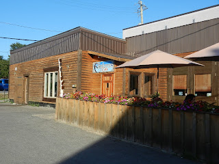
Midland was a together friendly small town. We found a unique restaurant called the Explorer’s Cafe and stopped for dinner. Here we had another unique experience when the gentlemen at the next table admired Kodi and we started chatting. Steve joined us at our table and ate with us. Steve was a clinical psychologist who evaluated mentally ill criminals who were committed to Canada’s mental health facilities. He also turned out to be an MSNBC viewer and an Obama supporter (unfortunately not able to vote). We had a lovely meal with a new friend.
Explorer's Cafe
Midland’s downtown was small but it had some colorful muriels painted on the walls. Here’s an example.
One of the many Midland murals
Kodi takes a break in the art shop
Written by Les.


No comments:
Post a Comment