Reader Notes: Rainy days are great for catching up, which I have. HURRAH!!!
- This is the third article published today. Be sure to read the other two; "A Friend Passes - Ronald D. Markovits" and "Good Friend & A Little Nostalgia - Hilton Head to Charleston, SC"
- This article is a little long and a bit technical. Hope you enjoy it.
However, we were not entirely looking forward to the journey from
Charleston to Norfolk, which we planned to do on the ICW. So we went back and reread our blog and we
were reminded of the ICW challenges of tricky navigation, skinny water,
currents and no wake zones. Hmm. We wondered if there was a reasonable
offshore alternative.
Note: Charleston is a great place but at this time of the year it is
full of bugs called no see-ums.
Explanatory Note: Cruising like life is full of
trade-offs. Traverse the ICW and you
cruise on calm waters with constantly changing scenery. But you trade that for tricky navigation,
skinny water, currents, no wake zones and the need to pay constant attention to
tides (especially now that we draw another foot of water - 5 feet on the 63
versus 4 on the 48). Operate on the
ocean and you get direct routes with deep water. But there are trade offs. You have to negotiate inlets, some of which
are very tricky (read as dangerous), add miles getting in and out of the inlets,
add distance as the inlets are relatively few and far between and finally, and
most critical, you have to deal with weather, wind and waves.
Readers will recall that we departed St Simon Island for Hilton Head on
calm waters and then after a two day stay departed Hilton Head for Charleston
on the same weather window. We checked
the weather on Saturday night to see if our weather window was still
“open.” It was.
According to Weather Underground, seas on Sunday were forecasted as 2
to 3 feet building to 3 to 4 feet on Monday on mild southeasterly winds (5 kts building to
15 kts ) and then increasing steadily to 5 to 7 feet as winds picked up 15 to 25 as a cold front approached from the
west. My take, there was 36 to 48 hours
remaining on the current weather window.
Explanatory Note: Heading
north east along the shore with a southeast wind is a favorable condition for
the 63. Waves were forecasted to be on
our beam which is optimum for the hydraulic stabilizers. I’ve had Guided Discovery out on a 6 foot
beam sea and she rode just fine.
Stabilizers are effective with seas from about 30 degrees to 150 degrees
on the beam. Following seas are OK too. The most difficult point of “sail”
is a head sea where the boat wants to pitch.
Stabilizers control roll. They
are and less effective with pitch and yaw.
The next question was where to go.
Below are the cities we visited on Great Loop between Charleston and
Beaufort, NC with the miles for each leg.
The trip is 235 nautical miles with four stops. I calculated the offshore run from Charleston
to Beaufort and determined 212 miles including the inlets at both ends. The difference is 23 miles which at 8 knots
represents three hours and 18 gallons of fuel.
Charleston
|
Georgetown,SC
|
56.8
|
Georgetown,SC
|
Myrtle Beach,SC
|
44.4
|
Myrtle Beach,SC
|
Southport,NC
|
38.2
|
Southport,NC
|
Wrightsville Beach
|
22.5
|
Wrightsville Beach
|
Beaufort, NC
|
72.2
|
Summary: We had a solid 24 hour weather window with an acceptable 24
hour cushion. We could save both travel
days, some long some short, and distance (fuel). We could get within 180 nautical miles of
Norfolk where we will meet Dick Singer and Phil Fuoco for the 500 mile offshore
run to the Cape Cod Canal. We could be
in a charming city (Beaufort) with a downtown dock and we could get out of
Charleston’s no see-ums (bugs that have been driving Diana crazy and a long
walk to town from the marina). If we
left at 10:00 AM we would get into Beaufort around 11:00 AM (assuming 8.4
knots at 1400 RPM). Tradeoff: 25 hours on the water with an overnight. Concern: Kodi has never eliminated on the
boat.
Night crossings have historically not been our thing. In fact Diana and I have only made one, a
five hour run from Chicago IL to Southhaven MI on the 44 Sundancer (at 20
knots) in circa 2002. I made one without
Diana from Mystic to Branford CT on October 10, 2011 to move the boat closer to
Yale New Haven Hospital after Diana’s knee injury (that ended our cruising
for 8 months). That run involved a
tricky night approach to an unfamiliar harbor.
Decision: Go! We could make the 25 hour run and arrive at Beaufort in daylight.
We moved the boat from our slip to the gas dock, which proved to be
tricky maneuver as we were against a wall with very little space to turn. Thanks to powerful thrusters I was able to
extricate us but it was definitely another learning experience.
Diana gave Kodi a walk while I fueled the boat. We took on 460 gallons at $4.05 per gallons,
the lowest we paid to date. While on the
walk Diana picked up some stones where Kodi had urinated in the hopes that it
would encourage her do so underway.
We departed at 10:28 AM and headed down the channel past Fort Sumpter
on an outbound tide. Good news: The 2.5 knot outbound current raised our speed to 11.0 knots
Bad news: The outbound current combined with the 10 knot easterly wind
produced 4 to 5 foot standing waves in the channel.
Guided Discovery pitched a bit, which scared the Furry
Kid. We passed the 900 foot Maersk Pittsburgh a
large container ship in the channel. She
threw a big wake (6 to 7 feet) but the stabilizers handled it.
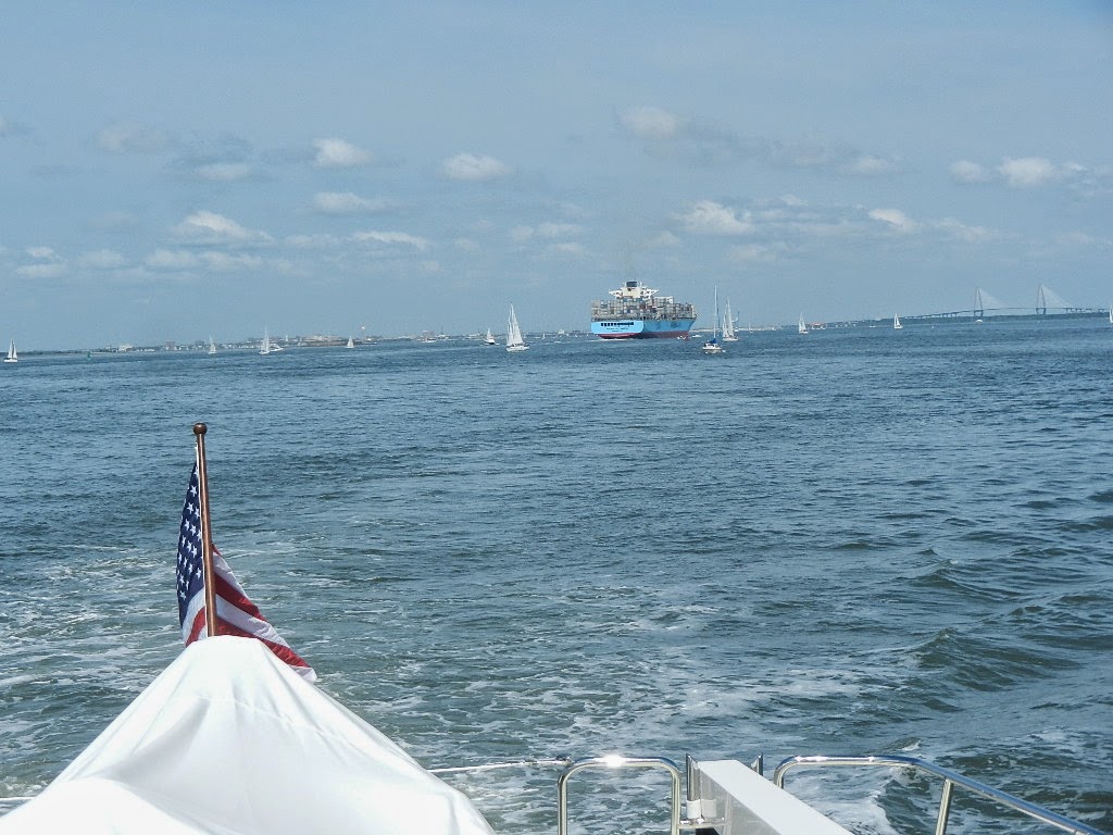 |
| We pass the 900 foot Maersk Pittsburgh |
At 11:18 AM we turned north and quickly were into the promised two foot seas, which were spaced 7 to 9 seconds apart. From there to the outer channel marker at the Beaufort Inlet, which we made at 10:25 AM on Monday, we headed northeast along the coast making only three minor course changes.
 |
| Our work area for the trip north |
 |
| Early afternoon. The left screen shows we're way south of Bald Head Island. The right screen is radar |
 |
| Nautical twilight. The left screen shows us at Bald Head Island. The right screen is monitoring weather |
 |
| Running in the dark. Radar and AIS are our eyes |
 |
| Just before sunrise. The left screen shows us 38.8 NM south of the Beaufort Inlet marker |
 |
| Red in the morning, sailor take warning - This ultimately proves to be true |
 |
| Sunrise (those are hard to see 4 to 5 foot swells) |
What's it like to run for 212 miles over 25 hours. The answer is easy when you do it in a 63 foot trawler equipped with good electronics, oversized stabilizers and relatively calm waters. While you are aware of the seas, the boats roll is negligible even when we encountered 5 foot swells on Monday morning. We operated from the pilothouse for 95% of the trip; both because of the temperature and the better working environment. The pilothouse is laid out so that everything I need is close at hand.
During the evening Diana took the helm to let me catch some sleep. I probably slept for 3 and a half hours and was very comfortable sleeping on the pilothouse settee.
I kept a log recording data so that I might be helpful. The data included:
- Time
- Position
- Course
- Speed
- Wave height
- Distance to next waypoint
- Distance traveled
- Wind direction and speed
- Barometer reading and direction (rising, steady, falling)
- Average speed
Explanatory Note: I've always been interested in weather since my days as a private pilot (1972 to 1983 - 1,300 hours including 300 plus of actual instrument time). As a cruiser since 1999, I've continued to pay close attention to weather. However, weather is somewhat transactional for the type of cruising we have done up until today. By transactional I mean you look at the current conditions and forecast and decide if you have enough good weather for the distance to be covered. Rarely did we run more than ten hours. Cruising overnight (and for longer as we plan to do from Norfolk to the Cape Cod Canal) one needs to be more strategic as weather and forecasts can change. Do I have enough good weather for the trip and a bit more for a margin of error? The longer the trip the greater the margin. Keeping track of weather trends while underway serves two purposes. One, to make tactical decisions to deal with changes and two, to improve one's judgment over time on the go/no go decision.
I also made engine room visits every three or four hours (wearing earmuffs made by Remington) to check for leaks and shoot temperature readings with a hand held pyrometer.
Explanatory Note: Handheld Infrared Thermometers are used to safely measure surface temperatures without making physical contact. Infrared thermometers measure the temperature from a distance by detecting the amount of thermal electromagnetic radiation emitted by an object.
Running at night. Radar and AIS serves as our eyes during the hours of darkness. Radar allows us to see other boats, land and navigation aids in relation to our course. AIS allows us to see other vessels that have the AIS (transponder) capability. This is particularly useful when encountering ships, which ALWAYS have AIS. AIS targets show up on the chartplotter as directional arrows. Green: No threat. Red: Watch out.
Explanatory Note: Heretofore I have only used radar in low visibility conditions. Rarely did I have it running when cruising along the Chicago lakefront and often wondered why people turned it on. On weekends there are so many targets that you would be hard pressed to use it intelligently. I just think people were showing off. Better to look out the window. As a result, my radar knowledge was very basic. Necessity is the mother of invention. Since getting the 63 I have been motivated to better understand radar and Garmin has made it easy by producing a very intuitive interface. I now can track targets, adjust the return for conditions and set up alarms.
We arrived in Beaufort at 11:50 AM and tied up a Beaufort Dock, a marina that sits of their main downtown business street.
Explanatory Note: Handheld Infrared Thermometers are used to safely measure surface temperatures without making physical contact. Infrared thermometers measure the temperature from a distance by detecting the amount of thermal electromagnetic radiation emitted by an object.
Running at night. Radar and AIS serves as our eyes during the hours of darkness. Radar allows us to see other boats, land and navigation aids in relation to our course. AIS allows us to see other vessels that have the AIS (transponder) capability. This is particularly useful when encountering ships, which ALWAYS have AIS. AIS targets show up on the chartplotter as directional arrows. Green: No threat. Red: Watch out.
Explanatory Note: Heretofore I have only used radar in low visibility conditions. Rarely did I have it running when cruising along the Chicago lakefront and often wondered why people turned it on. On weekends there are so many targets that you would be hard pressed to use it intelligently. I just think people were showing off. Better to look out the window. As a result, my radar knowledge was very basic. Necessity is the mother of invention. Since getting the 63 I have been motivated to better understand radar and Garmin has made it easy by producing a very intuitive interface. I now can track targets, adjust the return for conditions and set up alarms.
 |
| Lowe left: Radar showing navigational aids for an inlet Upper right: A target being tracked |
 |
| AIS data shows vessel name, size, heading, speed and proximity |
 |
| View of downtown Beaufort as we arrive |
 |
| Guided Discovery at Beaufort docks |
One concern: Kodi did not eliminate during the entire 25 hours despite our efforts and encouragement. Kodi as you know is highly trained. She is so incredibly housebroken. We need to work on this.
One negative. www.activecaptain.com, a wonderful website for cruisers that provides data on marinas, anchorages, hazards and local knowledge, that is constantly updated by cruisers like us, showed the marina's transient rate as $2.50 per foot ($158 per night). A bit expensive but OK it's close to town. When I got there the dockmaster told me the rate was $2.95 per foot ($186 per night). I mentioned that active captain showed a lower rate and further pointed out that they were less than 20% filled. I then got a song and dace that I could get a lower rate if I took a slip ($2.75). I did not have a good feeling about this and plan to write a negative review for active captain. This marina does not justify $3.00 a foot. The bathrooms are old and tired and not very clean (not that we need them but many smaller cruisers do).
Statistics:
- Nautical miles Charleston to Beaufort: 212.5
- Average speed: 8.4 knots
- Fuel consumption: 174.7 gallons
- Fuel efficiency: 1.22 NMPG
- Distance traveled since Fort Lauderdale: 747.3 NM (859 SM)
Written by Les.
No comments:
Post a Comment